Marty & Debbie's RV Adventure
Wednesday, August 23, 2006
Tuesday, August 15, 2006
Trip Update #5 (Dawson Creek, BC to Dawson City, Yukon)
The adventure picks up at Dawson Creek, British Columbia, which is the start (Mile 0) of the Alcan (Alaska) Highway. While we were in Alberta we started using our Milepost book. The Milepost is a road guide that covers points of interest, facilities, and history of not just the Alaska Highway, but also various approach routes from all directions. Everybody traveling the Alaska Highway seems to have one. Every year they publish a new version so most everything is up to date. We camped at a RV park in Dawson Creek using our Passport America campground membership discount…this is one membership that paid for itself in very short order. For $45 a year you get ½ off at select private campgrounds across the U.S. and Canada, though we’ve seldom used it in Canada, since there are few participating parks.
We bounced around Dawson Creek for a day making sure to snap our photo by the “Mile 0” arch, admire the many murals painted on the sides of historic buildings, and peruse an excellent historic photo exhibit of the construction of the Alaska Highway that was uniquely located in an old grain silo converted into an art gallery. The history behind the building of the Alaska Highway is quite interesting, especially to two civil engineers. There is a ton of information at roadside turnouts and visitor centers along the entire route detailing everything from the road’s politics to the hardships endured by the workers to the construction details. Oh, and while we were in Dawson Creek, we made the routine trip to WallyWorld (Walmart) to resupply for our journey into the northland…you never know where the next one will be. Many Walmarts, but not all, offer free overnight parking to Rvers. Some city ordinances prohibit this as they don’t allow any overnight camping, except within established campgrounds. We have yet to crash at a Walmart for an overnight, but it looks like a popular thing to do given all the RVs we see parked there.
We spent the first few nights of our journey on the Alaska Highway boondocking at spots that were listed in our Escapees Boondocking journal. One was at a viewpoint overlooking a big burn area near Pink Mountain and another at a Fort Nelson city park next to the baseball diamonds. Our third night was a beauty as we spent it on the shore of Muncho Lake, an unbelievably gorgeous body of water that is turquoise blue. Marty spotted a Canadian lynx while on a short hike above the lake, then managed to turn his ankle crossing a stream bed. Old ankle injuries seem to haunt you for the rest of your days, though they don’t seem to hurt as bad as the original one and thankfully, heal faster, too. The weather was stormy, otherwise we would have broken out the kayak, instead we headed about 50 miles down the road to Liard Hot Springs Provincial Park, which is definitely one of the highlights of the trip thus far (see the photos). Neither one of us had been to a hot springs where you could soak in such beautiful natural surroundings that weren’t developed into concrete or rock-lined pools. The “alpha” pools is where most people go to soak, however, there is a large upper “beta” pool that is equally spectacular and much more private. Unfortunately, the fatal bear mauling that occurred a year or so ago near the “beta” pool deters a lot of folks from venturing beyond “alpha” pool – chickens! The water in the springs was so hot that we could not get closer than about 25 feet to the source without becoming “lobster-ized”. We enjoyed it so much we went twice – once the afternoon we arrived with Marty hobbling up the ¼-mile long wooden boardwalk with a bum ankle and then again the next morning.
From Liard we cruised west into the town of Watson Lake, which was one of the main construction camps for the building of the Alaska Highway. We saw our first bear of the trip (a black bear cub), in addition to wood buffalo and a moose alongside the highway. Watson Lake is particularly know for its ‘Signpost Forest’ (see photo), where there is row upon row of poles with attached signs from all over the world. It is a bizarre place to visit as we hadn’t seen anything like it before. We found several signs from the Sacramento area. We did not come prepared with a sign, but we saw others preparing to fasten their signs that they brought with them (kind of touristy, eh?)…we didn’t see where there was any room left, however.
Near Watson Lake we crossed from B.C. into Yukon Territory and camped at a Yukon Territorial park situated on the banks of a very pretty creek and were subsequently overrun by mosquitoes…inside the trailer!! I mean, isn’t this one of the advantages of RVing versus tent camping? There must have been a couple hundred that had found their way in, and we could not figure out where they were coming from as all vents, windows, and doors were closed. We had noticed that they were swarming around the door. We went to bed that night with mosquito nets on and maxi-deet (this stuff is great – 95% deet!) sprayed liberally on exposed areas and ended up cursing the little bloodsuckers all night. We left quite early the next morning (earliest start of the trip), and camped at a fun place called Mukluk Annie’s a little past the town of Teslin. After setting up camp, we stayed inside the trailer for about 3 hours and did nothing except kill mosquitoes, carcasses everywhere…the carnage was visceral. Turns out there was about 2 inches of door weatherstripping that was missing and the skeeters were funneling right through there…a piece of duct-tape made for an expedient fix until we got to a hardware store. After vacuuming up the carcasses we took part in Mukluk Annie’s salmon bake (buy dinner and dry camp for free) and boat ride on the lake. Annie’s husband Chuck (Mukluk Chuck) captains the houseboat across the lake and tells some good animal stories about grizzlies and moose on the other side of the lake. We had a great time with Chuck and had fun with others making the trip to Alaska.
From there we cruised into Whitehorse, the capital of the Yukon Territory and located on the banks of the Yukon River. The population of the Yukon Territory is only 30,000 people (+/-) and 25,000 of those reside in the Whitehorse area. …talk about sparsely populated. We attended the Canada Day (equivalent of the 4th of July in the states) parade in Whitehorse the next morning and one of the locals asked us what the population of California was…we said about 34 million +/- and he said that was more than the entire population of Canada…quite a statistic if that is true! We had quite the time in Whitehorse doing the typical tourist stuff like taking a tour of the S.S. Klondike (a paddlewheeler) (Marty thought they’d give out free Klondike bars at the end of the tour but was sadly disappointed) and going to the Frantic Follies vaudeville theater, which was cheesy but fun. Whitehorse was one of the centers of the Klondike gold rush beginning in 1898 and still retains a lot of its charm. They also have a great bike path that circles around the Yukon River and takes you to the longest wooden fish ladder in the world located near the base of the hydroelectric dam…our timing was about a month off as the salmon would be arriving at the end of the month as part of their 3,000+ mile spawning migration…the longest salmon migration in the world. On the same bike path and adjacent to a roadside rest area was a mother bald eagle guarding her nest of eaglets high above the river. The next day our journey got a bit more interesting.
We went out again on the bike path the next day, with Debbie rollerblading and Marty biking. Turns out Debbie is pretty decent at rollerblading, except for when it comes to stopping. We were just ending our loop when Debbie bought the farm on a steep decline next to the S.S. Klondike…she went down in a hurry and her right wrist took the brunt of it. She had all the protective regalia on at the time (wrist guards, knee pads, elbow bads), however, the wrist guards apparently had too much flex in them to prevent her injury. After having broken her left wrist a few years back (remember that Joe and Paget?), Debbie was pretty sure she had done the same to her other one. So, we headed off to Whitehorse General Hospital ER, which was only a couple blocks away from the scene of the accident. The French-Canadian doctor, from Quebec, was very good-natured, but after x-rays revealed that it was a bad break, said that it was likely that Debbie would require surgery and that she would have to see an orthopedic surgeon either in Edmonton, Alberta or Anchorage, Alaska. He said there was no surgeon in Whitehorse that could perform this surgery. This was the capital of the Yukon Territory…capital of 30,000 people! Believe it or not, Anchorage is considerably closer to Whitehorse, only 720 miles away, plus the hospital was covered under our insurance. So, on July 4th we giddy-upped 720 miles and 15+ hours to Anchorage, leaving our trailer in Whitehorse. It was probably the most scenic 720 miles we could have hoped for under the circumstances. We got to the hospital in Anchorage (Alaska Regional) about 2:30 in the morning. We had an appointment for 7:30 with the orthopedic surgeon, so we crashed in the truck for the night and waltzed into the doctor’s office like we had just slept in our vehicle…classic! Three hours later Debbie was in surgery to insert a permanent plate that will stabilize her wrist. The hospital had rooms for out-of-towners on the 7th floor, so we stayed that night at the hospital and headed back to Whitehorse the next day. On the way back we saw moose and grizzly on the side of the highway near Kluane Lake and a lynx near Haines Junction…this is wild country! We made it back to Whitehorse about 3 in the morning darned tired and Debbie in considerable pain from her surgery…sometimes life ain’t so easy on the road.
We left Whitehorse a day or two later after securing provisions and a Yukon fishing license, and turned off the Alaska Highway onto the Klondike Highway, which heads north toward Dawson City. (Keep in mind there are two Dawson(s)…Dawson Creek, B.C. and Dawson City, Yukon Territory). We made two great sidetrips en route to Dawson City. The first was up the Silver Trail, which led to the gold and silver mining towns of Mayo, Elsa, and Keno Hill up the Stewart River. Not a lot of people make the drive to see this area, but we found it well worth it. Both Mayo and Keno Hill had excellent museums, with the mining museum at Keno Hill a real must-see. We camped at a Yukon government campground at Five Mile Lake that was more than half-empty. We had good luck fishing for northern pike from shore...we fished in the evening twice and caught enough for dinner within 15 or 20 minutes as they were striking our lure like crazy. I think in 4 casts we caught 3 fish. There is no fishing with live bait up here in the northland, so we’ve been getting accustomed to using lures. An annual non-resident fishing license in the Yukon is only $35, which is a bargain compared to Alberta, British Columbia, and especially Alaska ($145-yowza!..plus another $10 if you want to fish for king salmon). We’ll be driving through the Yukon again on our way back to the states, so we hope to try our luck again near the end of the summer. Atop the alpine tundra on Keno Hill are abandoned silver mining claims and old mine works that are fun to hike to and explore, with marmots and pikas chattering away in the rockpiles. After a couple of days on the Silver Trail we headed back to the Klondike Highway en route to our second sidetrip – the Dempster Highway.
For us, the Dempster offered us a chance to travel to the Arctic Circle…we had no intention of making it to road’s end at the town of Inuvik, 456 miles one-way on gravel road. We saw everything from cars, RVs, motorcyclists, and bicyclists making the trip. The Dempster is the only highway in Canada that crosses the Arctic Circle and is generally regarded as a legendary road trip in the north. Some travelers drive to Inuvik in the summer, then take float planes to see some additional villages and parks/marine sanctuaries on the Beaufort Sea. For those that don’t know, the Arctic Circle is a line that represents the farthest south location at which one can observe the “midnight sun”, that is on the summer solstice (June 21st), the sun never sets. Similarly, on the winter solstice, the sun never rises. We drove the first 45 miles of the Dempster towing the trailer and camped at Tombstone Territorial Park, which provides some of the most stunning scenery of the route. We drove the next day, leaving the trailer at Tombstone, through a stunning mix of glaciated and non-glaciated terrain on the way to Eagle Plains, where we tent-camped for a night. We bring all our camping equipment with us so we have the flexibility to take off and camp without the trailer. Eagle Plains is 229 miles up the Dempster and about 20 miles south of the Arctic Circle...it provides the only services between the start of the Dempster and Inuvik (456 miles). The Dempster is notorious for blessing motorists with flat tires, and sure enough, we had a flat about 60 miles out of Eagle Plains. We changed it out with the spare at a rest area, and had the flat repaired at Eagle Plains…they pulled out a small, sharp, rock fragment that had done the damage. Some people advise carrying more than one spare due to the notorious rock outcrops on the road and the long distance between towns. We had to wait over an hour for a deluge to end before we set up the tent at Eagle Plains and after an expedient gourmet supper of hotdogs and baked beans, we drove about 20 miles north to the Arctic Circle around midnight. Rather uneventfully, we snapped some photos, savored the moment and views of the rolling hills and tundra, and cruised back to camp. We saw surprisingly little wildlife on our trip north up the Dempster, but were delighted to see a lot of tundra moose on the return trip. On the way down we met a fun couple from Boulder, Colorado, who invited us over to their campsite that night to have dinner and share our stories of adventures on the road.
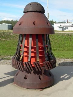
We left the Dempster Highway and headed west to another Klondike gold rush town – Dawson City. This would be our last stop before heading into Alaska. Dawson City was a lot of fun as we spent our time touring North America’s largest bucket-lined gold dredge, fishing the Klondike River, and watching the can-can girls kick up their heels during the free shows at Diamond Tooth Gertie’s Gambling Hall. We took in each of the three nightly shows as each one was different and we enjoyed the experience with a new round of fellow tourists surrounding us. Debbie lost $50 at the blackjack table in short order. We left somewhere after midnight and capped off the evening fishing (unsuccessfully) for Arctic Grayling, thoroughly enjoying the long hours of daylight that the northland brings. The next morning we crossed the Yukon River at Dawson City via a very short auto ferry and began our journey across the Top of the World Highway en route to Alaska (at last!-July 16, 2006).


