Trip Update #4 (Glacier Nat'l Park, MT to Dawson Creek, BC)
Hello everyone,
We’ve been on the road about 6 months now, during which we have gone through a couple of distinct phases. Hard to believe its been almost 6 months…time has flown by. The first month or two were the “celebration” phase of our trip and was more like a vacation, where the novelty of the adventure dominated our thoughts and we kept telling ourselves “I can’t believe we are actually doing this!”. It was also the phase where we got to experience 24/7 living with your spouse (in a 32-foot trailer!), which fortunately came relatively easy for us. The last couple of months has evolved into more or less normalcy as we have gotten more accustomed to this RV lifestyle. Despite the new sights to see and new people that you meet, a lot of the RV lifestyle is fairly routine…trips to the grocery store, stops at post offices and gas stations, fixing meals, cleaning dishes (miss the dishwasher!), cleaning the trailer, etc…not so much different than stationary living.
We track our expenses and keep an eye on our established monthly budget. We’ve learned the cost of RVing is a function of how much traveling you do. The more you travel the higher your fuel bill and also your camping fees. If you’re able to stay put, you’re not spending money on fuel and you’re also getting weekly or monthly rates on your camping. Unfortunately, we’re planning on logging a lot of miles this summer, so looks like the bank account will continue its negative trend. L
So….at the end of May we drove northward along the front range of the Montana Rockies to Glacier National Park and camped for a few nights on the east side of the park in an area known as Many Glacier. Going-to-the-Sun Road, which crosses the park, was still being plowed and wouldn’t open till mid-June the rangers told us. We figured that everything would be plowed by Memorial Day, but that is not the case here. The actual opening date is dependent on how much snow they receive, but the average opening date is mid-June. There is a more circuitous route between the two sides of the park, however, we decided we’d had enough driving and would concentrate our adventures on the east side. We were told the west side is more lush, however, the better mountain, glacier, and lake views are better on the east side…whether that’s true or not we don’t know. We figure we’ll hit the west side of the park on another visit. On our drive up the main road past St Mary’s Lake to the turnaround point it became clear that these small glaciers are mere remnants of the previous glaciation and are receding so quickly that they’ll be the size of icecubes in about 50 years…so if you want to see glaciers in the lower 48 go now, if not go to the Canadian Rockies, or better yet, Alaska! The highlight of our time in Glacier was on a drive back to our campsite our last night, where a handful of cars had pulled off to the side of the road…an amateur wildlife movie producer had a spotting scope on a tripod, where on one hillside we were able to see a mama Grizzly with two cubs, a small herd of Rocky Mountain Bighorn sheep, and a mother mountain goat with kid in tow. We thought we had seen a timber wolf a few days before on our way into the park, but after considerable discussions we wrote it off as a healthy and hefty coyote.
We crossed into Alberta at the Chief Mountain border crossing on June 1st without much fanfare, though we celebrated shortly after at a roadside turnout overlooking middle and lower Waterton Lakes and said a few “eh’s?”. We were anticipating the Holy Inquisistion, but it turned out rather anti-climactic. I guess we just don’t have that evil-doer appearance with the trailer in tow and Marty wearing a Hawaiian shirt. We flashed them our passports and they followed with limited questioning regarding possession of firearms, alcohol, and firewood. We had trucked in some firewood from the states, which we were forced to part with due to concerns of dutch-elm disease…that’s the breaks.
We stayed 3 nights in Waterton Lakes park at the Crandall Campground, which was the only camp located outside of the village, about 8 miles up a side-valley. As with Glacier, there is a seemingly infinite number of backcountry trails to explore, should you be willing to share them with the Grizzlies. Once we hit Glacier, we became aware that our position on the food chain had changed from No. 1 to No. 2. One thing we have learned about grizzly bears is that they are unpredictable…we absorbed as much as possible about actions to take when encountering one in the backcountry, though every situation is different. The weather at Waterton Lakes was a bit stormy for kayaking and we had to regretfully pass up beautiful Cameron Lake at the end of the road for another time. We broke out our fishing gear at a small glacial lake that we hiked into from the campground and didn’t even get a bite. After losing a lure and a bobbin, we beat feet for the campground, packed up the fifth wheel and headed north.
The fact that the drive along the western edge of the prairie paralleling the Candian Rockies is gorgeous is an understatement. What scenery! After filling up on propane, we dropped the trailer at a supermarket in Pincher Creek and made tracks along a gravel road to the Head-Smashed-In Buffalo Jump outside Fort McLeod, Alberta. This sight is one of the largest and best preserved buffalo jumps in North America, where the natives would channel the buffalo into lanes and drive an entire herd off a 30-foot cliff. The natives would be waiting at the bottom to polish off any animals that weren’t killed in the fall and then the butchering of the animals would ensue. None of the buffalo was wasted. The visitor center was architecturally beautiful and blended into the natural surroundings…5-levels built into the side of a hill with sod roofs. The exhibits were equally impressive and it was fun to linger on each level before descending stairs to the next one. We took a different route to Pincher Creek, hooked-up, and headed west to the Crow’s Nest area.
We camped for a few nights at a free municipal campground that had water and a dump station…this is a rarity and we weren’t complaining. Crow’s Nest is a mountain community not far from the continental divide and is assembled of at least four distinct towns, each with a coal-mining background. The main attraction is Frank Slide, an enormous rock slide that blanketed a good portion of the area with rock debris up to 100-feet deep…the stories behind the event were very interesting and there was another fantastic interpretive center operated by Alberta National Historic Sites. (Both of us feel that Albertans are the most amicable Canadians we have met thus far in our journey…at the time of this writing we have also passed through the northern portion of British Columbia and Yukon Territory). Alberta has a little of everything, minus the ocean…a lot like Colorado. We also visited the Leitch Colleries historic site, which was one of the bigger and most productive coal mines in the area, and learned a lot about coal-mining operations. There is another mine in town where you can take an underground tour, which we meant to do before Marty threw out his back putting away the damned satellite dish…by the way, Dish Network does work in southern Alberta though it is a real flat trajectory and it’s a crapshoot to find the satellite as Dish Network does not provide Canadian azimuth and elevation readings. It worked as far north as Calgary. If we keep RVing we might mount a dish on the roof and use the tripod as backup in case we’re blocked in with trees and need to run the coax to a clearing. While we were in Crows Nest area, we also happened upon a recent coal-train derailment. The accident had occurred earlier in the day and Canadian Pacific Railroad was on the spot with heavy equipment moving coal and freight cars aside so the twisted track could be replaced…check the blog for a photo. On to Calgary!
We thought we’d check out Calgary for a day or so, so we headed north up the Cowboy Trail. En route, we made a brief stop at a huge glacial erratic in Okotoks…geologists determined that this erratic was transported from the Jasper area via an alpine glacier and deposited onto the vast Laurentide ice sheet (a continental glacier). Check out the photo, its enormous! Calgary is situated about a couple hour’s drive east of Banff National Park on the prairie and is a big oil/gas town. We were early for the big Calgary Stampede, which doesn’t start till July, but we heard it’s a hoot. Being on a budget we zeroed in on some free stuff to do, which included a visit to Devonian Gardens. In finding a place to park we learned that there are no paper currency bills smaller than $5 in Canada, instead they have a $1 coin (called a “Looney”) and a $2 coin (called a “Tooney”). Devonian Gardens is an oasis in downtown Calgary and is surprisingly located on the third floor of a big mall. It is a large botanical garden with all sorts of blooming plants, ponds with turtles and koi, and fountains…indeed a peaceful respite and a great place we noticed for retail-workers to eat their lunch. After the gardens we visited a bird sanctuary east of downtown adjacent to the Bow River and made friends with some quackers.
Everything in Canada seems a small fortune compared to the states…anywhere between 10 to 50% more. The exchange rate helps a bit, but not as good as in years past. It really hits you at the grocery store and the pump.
After getting a taste of Calgary we drove a couple hours on the Trans-Canada Highway to Banff and settled into Two Jack campground. The gathering gloom had settled in on us with rain and low clouds. Unfortunately, this weather would persist more or less for the remainder of our stay at Banff with only a few brief breaks for sunshine. We chose this campground, located near Lake Minnewanka area (biggest lake in the area), due to a lot of wildlife in the area and being away from the town. We saw a ton of elk, including one group that seemed to pass through the campground on a regular basis. We also saw bighorn sheep and our first loon. We were able to see the mountaintops during breaks in the rain and it is breathtaking. During an unusually sunny afternoon we managed a short paddle on Vermillion Lakes, which is near the town, and saw more elk along the shores. We also had some mail forwarded to us at Banff, which never arrived by the time we left. We had to forward it along to the Yukon, where it finally caught up with us. We ended up suspending our Verizon Wireless internet service for the summer as they assess outrageous roaming charges (per kilobyte) outside of the states…so we’ll be dependent on free wi-fi hotspots for the rest of the summer, which is a little more of a hassle to find one that doesn’t require a log-in and is free (remember, we’re on a budget!).
We then headed up to the Lake Louise area (still in Banff), which is another hour or so up the Trans-Canada Highway and stayed there for a few nights. We managed a great hike that started at Lake Louise and climbed steeply to a small tarn (lake) with a teahouse. We shared a cookie and headed back down as we could see a storm quickly approaching…it came down in buckets on our way down. Our pants were soaked but it was relatively warm…ah, yes, a summer squall in the Canadian Rockies. There are definitely some great Class I floats to be had on the Bow River between Lake Louise and Banff Town…especially in June or early July, the water is high and fast, and there are several campsites on the river for doing an overnight. We were not able to find an outfitter that offered any kind of shuttle service nor any other campers interested in floating it, so we would have had to hire a taxi to pick us up at the take-out and bring us back to our truck at the put-in. Moraine Lake, a short drive from Lake Louise, was a beautiful place to visit, though mobbed with fellow tourists. I think next time we go to Banff, early September might be a good choice.
We left Banff in better weather and headed for Jasper Nat’l Park with gorgeous mountain scenery the entire route. After a night near the Banff/Jasper border and a walk on the Columbia glacier, we drove down the Athabasca River valley toward the town of Jasper and camped at the Parcs Canada Whistler campground for several nights. As with Banff and Waterton Lakes, the choices of trails here seem endless. We enjoyed the drive/hike to Angel Glacier and met a lady on vacation that worked as a dental hygienist in bush Alaska…she had been working for the government on a native reservation for a couple of years and wasn’t decided on whether she was going to stay there for long…seemed like she enjoyed the remoteness, to a certain degree. Our last full day at Jasper was sunny and we spent it going for a sublime paddle on Maligne Lake, probably one of the most photographed lakes in the world, as well as a hike up (and down) Maligne Canyon trail. This trail was spectacular with deep gorges cut into limestone with endless waterfalls and subterranean channels feeding water from 15 miles upstream…best of all we had it all to ourselves as it was getting late.
From Jasper we headed north to Grande Prairie, Alberta via the towns of Hinton and Grande Cache. We have an incredible compilation of free or near-free boondocking (dry-camping) sites throughout Canada and the U.S. that we obtained through our membership in the Escapees RV club. Members write in with new campsites found and/or confirmations of existing listings as things do change. We stayed at one such site outside of Grande Cache…some of the sites you’d never know were there as you go flying down the road at 55 mph, so its nice to know their whereabouts ahead of time.
The economy in Alberta is really humming these days, between oil, natural gas, forestry, agriculture, and tourism. Grande Prairie is definitely booming…a new Costco is an indicator. We hadn’t intended on staying in Grande Prairie overnight, but we ended up doing battle at an RV dealership to get our Interstate Batteries replaced under warranty as it was within the 12-month replacement period. The batteries would drain very quickly after being charged overnight, yet after charging they would read a full charge on a load-tester/volt-meter. The RV dealership parts manager claimed there was nothing with the batteries, but we think what was happening was that the volt-meter was reading a surface charge and not a true charge of the battery fluid (electrolyte). We bought a $5 electrolyte tester at an auto parts store and showed the parts manager that every cell in both batteries was dead as a doornail (what he should have done to begin with-claimed he didn’t have one) and only then did he pick up the phone and call Interstate Batteries to get the okay to replace them. We learned a lot about RV batteries, and the converter inside the RV in the process, but what a hassle. It wasn’t all bad in Grande Prairie, though, as Debbie and I celebrated our fourth anniversary with a nice dinner at The Keg, which served great steaks (Alberta beef is awesome!). The visitor center was also extremely friendly (typical of our experience with people in Alberta) and even put on a free barbecue with bison smokies produced from local bison farms, which we indulged in. The bison meat is very lean and tasty.
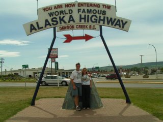
We left Grande Prairie with eager anticipation of the Alaska Highway, just a hundred or so miles away. We rolled past the largest beaver in Canada (we have a picture if anyone is really interested), a roadside attraction, en route to Dawson Creek, the start of the ULTIMATE ROADTRIP.


